
Buckle Up: Why 2026 Could Be America's Most Chaotic Weather Year Yet
Record-smashing heatwaves, severe storms and a looming El Niño are converging to make 2026 one of the most extreme US weather years on record.
When Mother Nature Decides to Multitask
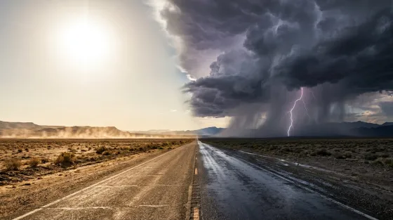
Picture this: one half of the United States is baking under a record-smashing heatwave whilst the other half is getting battered by blizzards and severe thunderstorms. Sound like a disaster film? It was just a regular week in March 2026.
Yuma, Arizona hit a staggering 109°F on 14 March, obliterating the all-time US national March temperature record of 108°F that had stood since 1954. Over 100 all-time March high temperature records were broken or tied across western and plains states, with temperatures running 20 to 40 degrees above average. Meanwhile, roughly 100 million people in the eastern US faced severe thunderstorm warnings, around 4,000 flights were cancelled nationwide, and more than 800 reports of damaging wind gusts rolled in from Texas to the East Coast.
If that sounds like a lot happening at once, well, that's rather the point.
El Niño Is Warming Up in the Wings
The real headline lurking behind all this meteorological mayhem is the growing likelihood of an El Niño event. NOAA's Climate Prediction Center has issued an official El Niño Watch, with a 62% probability of the phenomenon developing by June to August 2026. After a prolonged La Niña phase, the Pacific Ocean is gearing up for a potentially significant shift, and the consequences could ripple through weather patterns for the rest of the year and well into 2027.
For the uninitiated, El Niño occurs when sea surface temperatures in the equatorial Pacific rise above normal, triggering a cascade of atmospheric changes that can supercharge heatwaves, alter storm tracks, and generally make forecasters' lives considerably more interesting.
Some projections are even more dramatic. AccuWeather estimates a 15 to 22% chance of a Super El Niño developing, where ocean temperatures climb 2°C or more above normal. ECMWF models suggest an 80% chance of a strong El Niño forming. If the more aggressive forecasts prove correct, we could be looking at a weather pattern that makes 2026 feel like nature's stress test for modern infrastructure.
The Jet Stream Has Gone Rogue
A big part of the current chaos comes down to a disrupted jet stream. A lingering polar vortex core over North America, combined with an anomalous ridge of high pressure over the West, has created a situation where scorching heat and bitter cold exist in uncomfortably close proximity. When those air masses collide, the result is precisely the kind of violent storms that have been tearing across the eastern states.
Think of it as weather whiplash on a continental scale. The same atmospheric setup that gave Arizona its record-breaking March heatwave simultaneously fuelled blizzard conditions in the Great Lakes region. It is, to use a technical term, a complete mess.
Wildfire Season Is Already Knocking
The early heatwave has another troubling implication: fire season is arriving ahead of schedule. NOAA's fire weather outlooks flagged critical threats across the Northern High Plains, Central Rockies, and Southern Plains during mid-March, driven by the combination of extreme heat, dry conditions, strong winds, and low humidity. Climate change has been steadily pushing fire seasons earlier and making them more intense, and 2026 looks set to continue that unwelcome trend.
Hurricane Season Enters the Chat
As if heatwaves, storms, and wildfires were not enough to contend with, the Tropical Storm Risk forecasting group projects the 2026 Atlantic hurricane season will produce 14 named storms, 7 hurricanes, and 3 major hurricanes, with an ACE index of 125. An emerging El Niño typically suppresses Atlantic hurricane activity, but given that 2024 was the hottest year in recorded human history, all the usual rules feel slightly negotiable.
The Bigger Picture
Climate scientist Zeke Hausfather of Berkeley Earth has suggested that 2027 could end up being the warmest year on record if a strong El Niño takes hold, building on the heat already baked into the system. Daniel Swain of UC Agriculture and Natural Resources has explained how El Niño effectively releases stored ocean heat back into the atmosphere, amplifying existing warming trends.
None of this is speculation. The data is clear, the trends are established, and the events are already unfolding in real time. Whether you are in the path of a heatwave, a tornado, or simply trying to plan a barbecue, 2026's weather has one consistent message: expect the unexpected.
Read the original article at source.